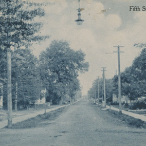
No street in Greenville has been more tied to East Carolina than Fifth. Prior to the school’s arrival in 1909, Fifth Street was well down Greenville’s list, behind Evans, Dickinson, Reade, and Cotanche Streets. With the Training School, Fifth emerged as the main east-west corridor, linking downtown with the new campus up Harrington Hill. The north side of East Fifth Street across from the Training School soon transformed from cotton, corn, and tobacco fields into a new neighborhood reflecting Greenville’s advance from an affluent farm town into a small but dynamic educational center.
In 1905, Fifth Street only comprised six blocks, from west of Pitt Street to east of Reade. At Reade, development stopped and the street vanished. Beyond was “a large field and narrow woods with dense underbrush.” Kate W. Lewis, a charter faculty member, recalled hearing of “splendid ‘possum hunts” in the woods east of Fifth Street’s end. Nearby was a convict camp. But just east of that inauspicious site, “forty-seven and one-half acres … was bought at $200 an acre” for the Training School. Fifth Street, a sandy road, was promptly extended eastward to access the campus site, first for construction and then for campus-community exchanges.
By 1911, two years after ECTTS opened, Greenville’s population had grown from 3,500 to 4,500. Also, Fifth Street extended eastward, the length of the Training School. Fourth Street grew eastward as well. Linking the two were new “avenues” running north-south: Holly, Summit, Jarvis, Student, and Biltmore. To the west, Fifth Street no longer turned into River Run after the Atlantic Coast tracks. Rather, it continued as Fifth into West Greenville, effectively spanning the town as the east-west corridor. Opposite the school near Fourth Street stood “two or three houses and a tall, shaky footbridge … across the ravine, … [plus] a rough steep path.” One house had belonged to a Mr. Yellowley, former owner of the property. That house, according to Lewis, was supposedly haunted, and so was not occupied for years.
By 1916, Third Street had grown eastward, paralleling Fifth and Fourth, and intersecting with Holly, Summit, Jarvis, Student, and Biltmore. The population of Greenville continued to escalate, reaching 5,000 by 1916. According to a 1916 Sanborn Map, most of the town streets were unpaved. Yet two years later, Lewis commented that Fifth had been a very “sandy road” until “splendid asphalt pavements … [had] taken the place of the sandy roads.” New businesses soon appeared catering to students, and old, disreputable ones such as the Rainbow Stables were torn down. And schools multiplied: at Fifth and Reade, proximate the Training School and also near where a convict camp once stood, the Greenville High School was built in 1918.
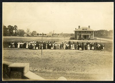
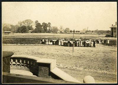
Most of the new development on Fifth Street eastward was residential. Construction of a wooden two-story home for President Robert H. Wright at Fifth and Jarvis across from the Administration Building was followed by a succession of new homes nearby. Behind the school, small lots on Eighth and Ninth Streets sold for $1,500-$2,000. By 1918, the asking price for the lot next to the President’s home was $5,000.00. Sale of just a few lots would have nearly equaled the price paid for the entire campus area ten years prior. East of the school had not been developed, leaving Fifth Street a dead end just past campus, and the students with an expanse of wooded countryside for hiking and relaxation.
Sources
- “From old Austin, looking toward President's House on 5th street.” University Archives # ECU/06. J. Y. Joyner Library. East Carolina University. Greenville, N.C. https://digital.lib.ecu.edu/835.
- “Greenville, Pitt County, North Carolina, January 1911.” New York: Sanborn Map Company. North Carolina Maps. Call # FFC912.74 G81.8. University of North Carolina at Chapel Hill. https://dc.lib.unc.edu/cdm/compoundobject/collection/ncmaps/id/2799/rec/7.
- “Greenville, Pitt County, North Carolina, February 1905.” New York: Sanborn Map Company. North Carolina Maps. Call # FFC912.74 G81.4. University of North Carolina at Chapel Hill. https://dc.lib.unc.edu/cdm/compoundobject/collection/ncmaps/id/7359/rec/8.
- Harding, F. C. “The School and the Town.” Training School Quarterly. Vol. 7, no. 1. October, November, December, 1919. Raleigh, N.C.: Edwards & Broughton, 1919.
- “In front of old Austin, looking toward 5th street and the President's home.” University Archives # ECU/06. J. Y. Joyner Library. East Carolina University. Greenville, N.C. https://digital.lib.ecu.edu/834.
- “Insurance Maps of Greenville, Pitt Co., North Carolina, May 1916.” New York: Sanborn Map Company. North Carolina Maps. Call # FFC912.74 G81.5. University of North Carolina at Chapel Hill. https://dc.lib.unc.edu/cdm/compoundobject/collection/ncmaps/id/7318/rec/16.
- Lewis, Kate W. “The Neighborhood as it was and is.” Training School Quarterly. Vol. 7, no. 1. October, November, December, 1919. Raleigh, N.C.: Edwards & Broughton, 1919.
Additional Related Material
Citation Information
Title: Fifth Street
Author: John A. Tucker, PhD
Date of Publication: 6/11/2018